The Lawers Range Twice: Five Munros Out and Back
Ten Munro summits in one outing on the highest ground in the southern Highlands, and you cross An Stuc's eroded crux four times. There is no harder day on this site.
Effort: Shorter distance, major ascent
Underfoot: Exposed, scrambling or very rough
E5·T5 — how we grade routesNo photos of this route yet. Sign in to add one
A real mix of running and walking — expect significant climbing.
33.2km and 2,942m of climb from the Ben Lawers NNR car park, traversing Beinn Ghlas, Ben Lawers, An Stuc, Meall Garbh and Meall Greigh to Loch Tay, then turning round and doing the whole range again in reverse. Ten Munro summits.
Ten Munro summits in one outing on the highest ground in the southern Highlands, and you cross An Stuc's eroded crux four times. There is no harder day on this site.
The route
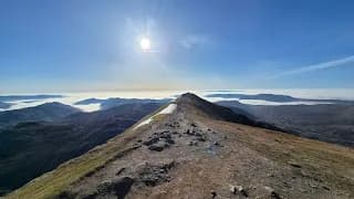
From the National Trust for Scotland car park at 400m the rebuilt stone path climbs through a fenced grazing exclosure onto Beinn Ghlas at 1,103m, reached at 4km. The difference in vegetation either side of that fence tells you why this is a National Nature Reserve. A clear ridge path carries on over the col to Ben Lawers at 1,214m, the tenth highest Munro and the highest ground in the southern Highlands, at 6km. That is the last of the good path.
An Stuc
Beyond Ben Lawers the route drops over Creag an Fhithich to the Bealach Dubh and pulls up An Stuc's southern slope on a steep crumbly track to the summit at 1,117m. The crux is on the far side. The descent north to Meall Garbh is an ill-defined, eroded gully, loose, near-permanently wet, moderately exposed and about grade 1 scrambling. It takes roughly twenty minutes and it is the only genuinely difficult ground on the whole ridge. The bypass to the east is often blocked by a cornice until early summer. On an out-and-back you cross it four times.
The eastern ridges
From Meall Garbh at 1,123m the character changes to broad grassy whaleback, boggy in the col, with only an intermittent path out to Meall Greigh at 1,001m and 12km. Then a sustained, pathless drop down the steep grass of Sron Mhor and a path beside the Lawers Burn past old shielings to the turn at 185m above Lawers on Loch Tay, 16.6km in. Then you go back over all of it.
Be honest with yourself
2,942m of climb is more than most people do in a week. Roughly 10km of ridge in each direction has no reliable running water, so refill at the Lawers Burn. Stay on the paths where they exist - over 40,000 people a year use the lower slopes and the arctic-alpine flora here, including bristle sedge found nowhere else in Britain, is what the reserve exists to protect.

Partner · affiliate policy
An Stuc's north side is a loose, eroded, near-permanently wet grade 1 scramble with moderate exposure, crossed four times on this route, and the bypass east of it is often blocked by a cornice until early summer. The Meall Garbh and Meall Greigh tops are broad and featureless and most incidents on this range come from people losing their way in mist. The Sron Mhor descent is around 800m of steep pathless grass, done twice. Red deer stalking runs through October and from mid-January to mid-February.
Summits on this route
Safety on this route
- No signal? Text 999 — pre-register first: text register to 999
- Tell someone your route and expected return time before you head out
Leave No Trace
- Leave nothing but footprints, take nothing but memories.
- Please respect the countryside and all its inhabitants.
- Dogs on leads near livestock, and around ground-nesting birds from March to July.
- Gates as you find them — open or closed, leave it that way for the farmer and the next runner.
- Take it all home — wrappers, peel, tissue, the lot. It doesn't count as biodegradable if you can still see it.
- Stick to the path where the ground either side is wet, planted, or nesting habitat.
Common questions
- Most runners complete The Lawers Range Twice: Five Munros Out and Back in 6 hours 10 minutes to 8 hours 25 minutes, depending on pace and conditions.
GPX checked
Distance, ascent and grade are calculated from the GPX file. Nobody has run this one for us yet, so treat the description as a plan rather than a report. How we check routes
About the author
Runner reports
Nobody's logged a run here yet. If you get out on it, a few lines about how it went helps the next person plan their day.



 VERY HARD
 HARD
HARD