Skipton to Malham via Canal and Pennine Way
You start on a flat canal towpath and finish in Malhamdale, with the Pennine Way's National Trail waymarking doing the navigation for you almost the entire way.
Effort: Good distance, solid climb
Underfoot: Some uneven or off-path ground
E3·T2 — how we grade routesYou start on a flat canal towpath and finish in Malhamdale, with the Pennine Way's National Trail waymarking doing the navigation for you almost the entire way.
A point-to-point route from Skipton to Malham, following the canal out of town before picking up the Pennine Way into Malhamdale. 17.7km, 78m of ascent, finishing in one of the Dales' best-known villages.
The route
This route leaves Skipton on the Leeds and Liverpool Canal towpath before peeling off to join the Pennine Way, following the National Trail through Craven's farmland and into Malhamdale. At 17.7km with just 78m of ascent, it's a gentle route by distance-to-climbing ratio, and most of the effort is in covering the ground rather than fighting gradient.
Canal to trail
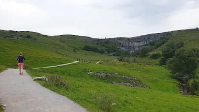
The opening section on the canal is flat and fast, a good way to settle into a rhythm before the terrain changes. Once you join the Pennine Way, the going shifts to field paths and farm tracks, crossing the Aire and threading between drystone walls on the approach to Malham. The Pennine Way's waymarking is consistent throughout this stretch, so route-finding stays straightforward even without much local knowledge.
Malham
The route finishes in Malham, a village that sits at the heart of some of the most photographed limestone scenery in the Dales, though this particular route doesn't climb up to Malham Cove or Janet's Foss - it delivers you to the village itself. The Buck Inn and the Lister Arms are both well-established stops for food, and the Old Barn Cafe is a good lower-key option if you'd rather not sit down to a full pub meal.
Getting there and back
Because this is a point-to-point route, you'll need a plan to get back to Skipton - there's no direct rail link to Malham, so a car shuttle or a pre-arranged lift is the practical option. Field paths can hold water and turn muddy after sustained rain, particularly in the lower sections near the Aire.
Why it works
This route earns its place as an easy-paced, low-stress long run - the navigation is largely done for you by the National Trail waymarking, the climbing is minimal, and the destination is one of the best-loved villages in the Dales. It's a good choice for runners who want distance in the legs without a fight over difficult terrain.
Field paths near the Aire can flood and turn muddy after sustained rain. This is a point-to-point route with no direct public transport back to Skipton, so arrange return transport before setting off.


Common questions
More routes in Yorkshire Dales
 HARD
HARD EASY
EASY VERY HARD