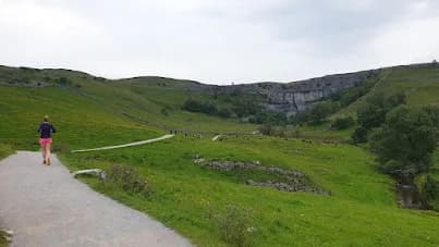
Malham Cove and Malham Tarn
The classic Malham circuit, joining the cove, its dramatic limestone pavement and the glittering tarn into one flowing mid-distance loop.
The classic Malham circuit, joining the cove, its dramatic limestone pavement and the glittering tarn into one flowing mid-distance loop.
A 16.5km loop from Malham linking the limestone amphitheatre of Malham Cove with the upland water of Malham Tarn, on a mix of pavement, dry valley and open track.
The route
This 16.5km loop is the definitive tour of upper Malhamdale. From the village you climb to the top of Malham Cove, where the limestone pavement opens out in clints and grikes above the 80m cliff. The route then threads the dry valley of Watlowes, a curving limestone canyon left behind by vanished meltwater, before opening onto the moor toward Malham Tarn.
The tarn
Malham Tarn sits at around 375m, one of England's highest natural lakes and a National Nature Reserve rich in birdlife. The track around its shore gives easy, scenic running and a real sense of remoteness despite the modest distance. From the tarn the loop turns back south, with high ground giving long views down the dale before the descent returns you to Malham village past the foot of the cove.
Why it works
The appeal here is variety packed into a manageable distance. You get the showpiece geology of the cove and pavement, the hidden drama of Watlowes, and the open calm of the tarn, all on generally good surfaces with no serious technical ground. It is a brilliant introduction to Dales fell running and a route that stays rewarding however many times you run it. Mind the limestone pavement at the cove top, which is slick and uneven when wet, and run early to beat the summer crowds.
Getting there
Malham village is the natural base, with a National Park car park, toilets, cafes and two pubs. The free Watersinks car park higher up offers an alternative start closer to the tarn if the village is full. Much of the route follows the Pennine Way, so the navigation is generally clear, but the moorland between cove and tarn is open and exposed, so carry an extra layer even on bright days.
The limestone pavement at the top of Malham Cove is uneven and very slippery when wet, with a sheer drop at the cliff edge. Upper sections are exposed to weather.


Common questions
More routes in Yorkshire Dales
 HARD
HARD HARD
HARD MODERATE