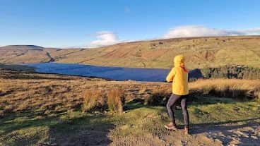
Scar House Reservoir Moorland Loop
You start beneath the huge stone dam of Scar House and head out across the empty grouse moor at the very head of Nidderdale, about as remote as the Dales get.
Effort: Good distance, solid climb
Underfoot: Some uneven or off-path ground
E3·T2 — how we grade routesNo photos of this route yet. Sign in to add one
An 18.1km loop from Scar House Reservoir at the head of Nidderdale, heading out from the great stone dam onto the wild moors on reservoir track and open ground, with 434m of climbing. Remote, quiet upper-dale running.
You start beneath the huge stone dam of Scar House and head out across the empty grouse moor at the very head of Nidderdale, about as remote as the Dales get.
The route
Start from the reservoir car park at the head of the private road above Lofthouse, beneath the great dam of Scar House Reservoir. From there the loop heads out onto the surrounding moors rather than around the water, an 18.1km circuit of reservoir track and open moor at the head of Nidderdale. The early sections run fast on made track, while the moor turns rougher and boggier underfoot, with 434m of climbing spread gently through the loop rather than in any single pull.
Scar House
Scar House and its neighbour Angram were built in the early 20th century to supply Bradford, huge feats of stone engineering at the remote head of the dale. The Scar House dam is a monumental thing, and the navvy village that built it has long since vanished back into the moor. Above the reservoirs the fells rise to the watershed with Wharfedale, empty grouse moor where the Nidd begins, all big skies, curlew and the constant sound of water.
Why it works
This is a route for a long, quiet day away from the crowds. The track sections give fast, easy running and the moor gives the loop its wildness and variety, without ever being technical. Navigation is straightforward on the track but needs more care on the open moor in cloud. It suits a steady long run or an easy big-distance day.
Good to know
Start from the Scar House Reservoir car park, which has toilets, a rare luxury this far up the dale. There is nothing else out here, so carry what you need; Lofthouse and Pateley Bridge are the nearest villages. The moor is boggy and exposed with no shelter, and the weather turns quickly at the head of the dale, so go prepared and pick a clear day. Grouse shooting affects the moors between August and December.

Partner · affiliate policy
The moor sections are boggy and exposed, needing care in cloud, and there is no shelter or facilities beyond the car park. Weather turns quickly at the head of the dale. Grouse shooting affects the moors between August and December.
Safety on this route
- No signal? Text 999 — pre-register first: text register to 999
- Tell someone your route and expected return time before you head out
Leave No Trace
- Leave nothing but footprints, take nothing but memories.
- Please respect the countryside and all its inhabitants.
- Dogs on leads near livestock, and around ground-nesting birds from March to July.
- Gates as you find them — open or closed, leave it that way for the farmer and the next runner.
- Take it all home — wrappers, peel, tissue, the lot. It doesn't count as biodegradable if you can still see it.
- Stick to the path where the ground either side is wet, planted, or nesting habitat.
Common questions
- Most runners complete Scar House Reservoir Moorland Loop in 2 hours 20 minutes to 3 hours 10 minutes, depending on pace and conditions.
Run by us· last checked July 2026
Jason Millward has run this route and written it up from the ground. How we check routes
About the author
Runner reports
Nobody's logged a run here yet. If you get out on it, a few lines about how it went helps the next person plan their day.



Routes nearby
Start from a town: Kettlewell 9.3 km · Grassington 14.5 km
 EXPERT
 VERY HARD
 VERY HARD
 EASY
EASY HARD
HARDRaces on this ground
All Nidderdale races →Races starting within 20 km of the Scar House Reservoir Moorland Loop start, nearest first. If you are entered for one, this route is the rehearsal.
24
Oct
2026
Nidderdale Way
Pateley Bridge, North Yorkshire · Punk Panther · 8 miles away
The full Nidderdale Way at fifty-six miles, or a bite of it. Punk Panther's longest.
HARD TO EXPERT
Entries open
17
Oct
2026
Ultra Tour of the Yorkshire Dales
Devonshire Institute, 48 Main Street, Grassington, North Yorkshire · Due North Events · 9 miles away
Grassington to Malham Tarn, Arncliffe and Wharfedale, with route choice between checkpoints.
VERY HARD TO EXPERT
Entries open