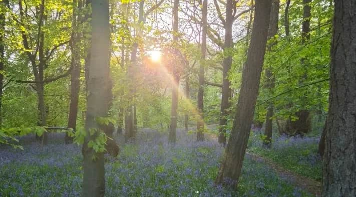
Middleton Woods and Nesfield from Ilkley
Middleton Woods is the largest ancient woodland left in West Yorkshire, and for about two weeks around late April the whole floor turns blue. Run it then and you will not miss having a summit.
Effort: Short distance, minimal climb
Underfoot: Some uneven or off-path ground
E1·T2 — how we grade routesNo photos of this route yet. Sign in to add one
A 7.8km loop from Riverside Gardens in Ilkley, crossing the Wharfe and climbing through Middleton Woods to the fields above Nesfield before returning along the river past the Old Bridge. 117m of climb and nothing steep.
Middleton Woods is the largest ancient woodland left in West Yorkshire, and for about two weeks around late April the whole floor turns blue. Run it then and you will not miss having a summit.
The route
From Riverside Gardens the route runs east along the Wharfe for a kilometre, crosses to the north bank and climbs away from the water at Curly Hill by 1.3km. That is the only real gradient of the day and it is done inside a few hundred metres.
Middleton Woods
By 1.9km you are into the trees. Middleton, Coppy, Stubham and Hudson woods together form the largest remaining ancient semi-natural woodland in West Yorkshire, 38 hectares of it, left to Bradford Council in 1937 by a wool merchant named Arthur Hentzen. The running is soft and rooty on broad tracks and narrower paths, with stream crossings and a few flights of rough steps. In late April and early May the bluebells are the reason anyone comes, and there is wild garlic, wood anemone and wood sorrel in with them. The high point of the route, 180m, arrives at 2.7km on open ground above the trees.
Nesfield and the river
The route drops west out of the woods to Nesfield at 4.2km, a hamlet of a few houses on the north bank road, then turns back southeast on field paths and riverside track. It recrosses the Wharfe at Ilkley Old Bridge at 7.3km. That seventeenth-century packhorse bridge is the official start of the Dales Way, which runs 78 miles from here to Bowness-on-Windermere, and it is a good deal older than anything else on this route bar the trees. The last few hundred metres follow the river back to the car park.
Who it suits
This is the route to hand someone who has never run off road. It is short, the paths are obvious for nearly all of it, it never gets more than about 110m above the river, and there is a cafe, a playground and a toilet at the finish. It is also the obvious wet-weather or short-daylight option in Ilkley when the moor is a bog.

Partner · affiliate policy
The woodland paths carry roots, rough steps and stream crossings and turn greasy after rain, which is the main thing likely to catch you out on ground this gentle. Bracken on the valley sides is prime tick habitat from spring onwards, so check afterwards. The bluebell weeks bring a lot of people into a small wood, so keep off the flowers and expect to give way.
Safety on this route
- No signal? Text 999 — pre-register first: text register to 999
- Tell someone your route and expected return time before you head out
Leave No Trace
- Leave nothing but footprints, take nothing but memories.
- Please respect the countryside and all its inhabitants.
- Dogs on leads near livestock, and around ground-nesting birds from March to July.
- Gates as you find them — open or closed, leave it that way for the farmer and the next runner.
- Take it all home — wrappers, peel, tissue, the lot. It doesn't count as biodegradable if you can still see it.
- Stick to the path where the ground either side is wet, planted, or nesting habitat.
Common questions
- Most runners complete Middleton Woods and Nesfield from Ilkley in 55 minutes to 1 hour 15 minutes, depending on pace and conditions.
GPX checked
Distance, ascent and grade are calculated from the GPX file. Nobody has run this one for us yet, so treat the description as a plan rather than a report. How we check routes
About the author
Runner reports
Nobody's logged a run here yet. If you get out on it, a few lines about how it went helps the next person plan their day.



Routes nearby
Start from a town: Ilkley 0.3 km · Skipton 13.3 km
 HARD
HARD HARD
HARD HARD
HARD MODERATE
 MODERATE
 HARD
HARDRaces on this ground
All Yorkshire Dales races →Races starting within 20 km of the Middleton Woods and Nesfield from Ilkley start, nearest first. If you are entered for one, this route is the rehearsal.
14
Aug
2027
Ilkley Skyline
The Hermit Inn, Moor Rd, Burley Woodhead, Burley in Wharfedale, Ilkley · Great Owl Running · 3 miles away
Unmarked 35km fell round of the moors above Ilkley, plus a 21km half
Not open yet
£25
17
Jun
2027

Bingley Rock Up n' Run
Five Rise Locks, Beck Lane, Bingley · It's Grim Up North Running · 5 miles away
A midweek summer evening 10k on the Leeds & Liverpool towpath from Five Rise Locks. Register from six, pay on the night, jumble medal and hot food after.
Entries open
£17
7
Nov
2026
The Grim Reservoir Dogs
Swinsty & Fewston Reservoir car park, North Lane, near Otley · It's Grim Up North Running · 5 miles away
A run with your dog round Swinsty and Fewston reservoirs on good woodland trail, one 3.3-mile loop or two. A fun dog race, not run under canicross rules.
Entries open
£18–£29
7
Nov
2026
Swinsty & Fewston Lakeside Dash
Swinsty & Fewston Reservoir car park, North Lane, near Otley · It's Grim Up North Running · 5 miles away
The 6.7-mile loop of Swinsty and Fewston reservoirs on well-kept trail, run once, twice, three or four times for the half, the twenty and the marathon. Everything starts at nine.
Entries open
£29–£43