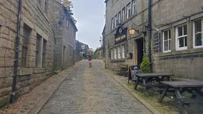
Heptonstall and Hardcastle Crags
You get the full Calderdale contrast in one loop: the deep, wooded gorge of Hardcastle Crags and the wild open moor above, joined by the cobbled hilltop village of Heptonstall.
No photos of this route yet. Sign in to add one
A 24km loop from Heptonstall above Hebden Bridge, linking the wooded ravine of Hardcastle Crags with the open Calderdale moors. Steep-sided South Pennine running with big climbs out of the valleys.
You get the full Calderdale contrast in one loop: the deep, wooded gorge of Hardcastle Crags and the wild open moor above, joined by the cobbled hilltop village of Heptonstall.
The route
Start from the hilltop village of Heptonstall and drop into the valleys around Hebden Bridge, taking in Hardcastle Crags before climbing onto the open moor to close a 24km loop. This is classic South Pennine terrain, where every valley means a steep climb out the other side, so the route feels tougher than a flat 24km and rewards strong legs on the ascents.
Hardcastle Crags
Hardcastle Crags is a deep, wooded ravine of oak, beech and pine cut by Hebden Water, with more than 15 miles of paths and the old Gibson Mill at its heart. It is one of the finest patches of woodland in the South Pennines and a cool, sheltered contrast to the exposed moor above. The route uses the valley paths before hauling up onto the tops, where the ground opens to heather, peat and the long views that define this corner of West Yorkshire.
Why it works
This is a proper Calderdale outing, honest about its climbs and varied in its ground. The woodland paths are good but rooty and can be slick; the moor is boggy and exposed, with navigation needed where paths fade in cloud. It suits a strong long run or a hard training day, and Hebden Bridge below is one of the best small towns anywhere for a post-run feed. Heptonstall itself, with its cobbles, ruined church and Sylvia Plath's grave, is worth time at either end. Save the moor sections for reasonable weather, carry a map, and expect wet feet whatever the forecast. This is a route that rewards fitness on the climbs more than speed on the flat, which is Calderdale running in a nutshell.

Partner · affiliate policy
The open moor is exposed and boggy with paths that fade in cloud, so carry a map and compass. Woodland paths are rooty and slick when wet, and the steep valley sides are hard on tired legs. Grouse shooting affects the moors between August and December.
Safety on this route
- No signal? Text 999 — pre-register first: text register to 999
- Tell someone your route and expected return time before you head out
Leave No Trace
- Leave nothing but footprints, take nothing but memories.
- Please respect the countryside and all its inhabitants.
- Dogs on leads near livestock, and around ground-nesting birds from March to July.
- Gates as you find them — open or closed, leave it that way for the farmer and the next runner.
- Take it all home — wrappers, peel, tissue, the lot. It doesn't count as biodegradable if you can still see it.
- Stick to the path where the ground either side is wet, planted, or nesting habitat.
Common questions
- Most runners complete Heptonstall and Hardcastle Crags in 3 hours 20 minutes to 4 hours 30 minutes, depending on pace and conditions.
Run by us· last checked July 2026
Jason Millward has run this route and written it up from the ground. How we check routes
About the author
Runner reports
Nobody's logged a run here yet. If you get out on it, a few lines about how it went helps the next person plan their day.



Routes nearby
 HARD
HARD VERY HARD
 MODERATE
 VERY HARD
 VERY HARD
 HARD
HARDRaces on this ground
All South Pennines races →Races starting within 20 km of the Heptonstall and Hardcastle Crags start, nearest first. If you are entered for one, this route is the rehearsal.
12
Dec
2026
Moors The Merrier 21
Mytholmroyd Community Centre · Cragg Runner · 2 miles away
Twenty-one miles round the moors above Hebden Bridge in December, in a Santa hat, with a present for the bran tub.
Entries open
8
Nov
2026
Soyland Moor
Hinchliffe Arms, Cragg Vale · Cragg Runner · 3 miles away
Thirteen and a half miles of fell over Soyland Moor from the Hinchliffe Arms at Cragg Vale, under FRA rules.
Entries open
31
Oct
2026
Race You To The Summit
Summit Inn, Littleborough · Cragg Runner · 6 miles away
A four-mile Halloween fell race from the Summit Inn at Littleborough, with eight hundred feet of climb in it.
Entries open
26
Sept
2026
Burnley Way Ultra & Off-Road Marathon
Finsley Gate Wharf, Burnley · Run JMC · 9 miles away
Forty miles or twenty-seven of moorland, towpath and field along the Burnley Way, out of Finsley Gate Wharf.
Entries open